
South East Queensland is preparing for it’s first Tropical Cyclone in decades. Cyclone Alfred is now tipped to make landfall somewhere between Brisbane and the Sunshine Coast late Thursday or early Friday.
Get live updates on Cyclone Alfred as well as useful resources to help you be as prepared as possible.
🔴 LIVE UPDATES 🔴
Queensland Updates: Hotline, Flooding, and Recovery Efforts
QLD Emergency Hotline
The state has launched a hotline to assist those impacted by Cyclone Alfred and its aftermath.
- 800 staff are on hand to provide support.
- Assistance ranges from mental health support to insurance queries.
- Hotline number: 1800 173 349.
Rain and Flooding
Brisbane has recorded over 260mm of rain in the past 24 hours, leading to flooding in homes and businesses in high-risk areas.
Emergency alerts issued overnight:
- Dangerous flooding: Tamborine to Beenleigh, Greenbank, New Beith, and Forestdale in Logan.
- Take shelter now: Laidley.
- Too dangerous to leave: Northern Gold Coast, including Luscombe, Yatala, Stapylton, Alberton, and Gilberton.
Schools Update
- Schools are reopening where safe, but 684 remain closed today (down from over 1,000 last week).
- NAPLAN, originally set to begin Wednesday, can now start from next Monday in affected schools.
Power Outages
- 210,000 properties in SEQ remain without power.
- Crews are gradually restoring electricity, down from 320,000 outages on Sunday.
Missing Teenager – Logan Reserve
Search efforts are underway for an 18-year-old man who went missing in Logan Reserve around 11 PM last night.
- Last seen wearing camo shorts, no shirt, and no shoes.
- Swiftwater rescue teams are assisting SES and police in the search.
Saturday March 8th
Ex-Cyclone Alfred has downgraded to an ex-tropical cyclone before crossing the mainland. It is currently near Bribie Island, with winds of approximately 85 km/h.
Authorities have confirmed that no lives have been lost, and no one has been reported missing in Queensland.
Premier David Crisafulli says that because the storm did not cross the coast at high tide, many Queenslanders have been spared from major flooding.
Heavy Rain and Flooding Risks Continue
The system is expected to move west throughout the day, bringing heavy rain later on. Officials are urging residents to remain bunkered down.
Brisbane Lord Mayor Adrian Schrinner told Robin, Kip, and Corey Oates that while there is a sense of relief after avoiding the worst, the risk of rain and flooding is still very real.
Widespread Power Outages
Around 263,000 people in southeast Queensland are without power, and that number is expected to rise.
Chris Graham from Energex told Robin, Kip, and Corey Oates that residents should prepare for prolonged outages.
Danny Donald from Energex says they anticipate at least 1,000 power lines will be down across the region, but conditions remain too dangerous for crews to begin restoration work.
Friday March 7th
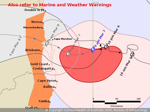
Cyclone Alfred, a category two system, is currently about 195 kilometers east of Brisbane and 180 kilometers east-northeast of the Gold Coast. It has slowed slightly, now moving at just 6 km/h.
Landfall is most likely expected in Moreton Bay, with the impact zone stretching between Noosa and Coolangatta.
An estimated 4.5 million people are in the cyclone’s path, from the Sunshine Coast down to Coffs Harbour.
Widespread power outages have already affected 20,000 properties across Queensland and New South Wales. On Thursday alone, the SES received over 700 calls for assistance.
As conditions remain calm before the storm, the Bureau of Meteorology is urging residents not to be complacent.
Brisbane Flooding Risk
A 1.5-meter storm surge is possible if the cyclone crosses at high tide.
Additional properties have now been included in Brisbane’s flood modelling—residents are urged to check updated maps to see if their homes are at risk.
Brisbane Sandbag Update
All Brisbane sandbag sites are now closed, with over 400,000 sandbags collected.
No sandbag stations will reopen tomorrow due to safety concerns.
Brisbane Closures
- Public transport has been paused
- Schools are closed
- Elective surgeries have been postponed
- Australia Post has halted operations, with post offices now closed
- Roads and critical infrastructure will remain open as long as possible
Gold Coast Impact
- 100 km/h winds recorded in Coolangatta
- Around 20,000 homes on the Gold Coast are without power
- 12.4-meter waves recorded, though the instrument measuring them has been damaged by the swell
- Beaches are experiencing severe erosion
Sunshine Coast Impact
Conditions are expected to deteriorate, with significant beach erosion likely.
Some beaches could lose up to 40 meters of sand, and Bribie Island has already broken through.
Brisbane Airport Closures
- Virgin Australia has suspended all flights to and from Brisbane, the Gold Coast, and Ballina on Friday and Saturday, with plans to resume operations on Sunday when safe.
- Qantas and Jetstar have suspended all domestic flights from Brisbane, Gold Coast, and Ballina until at least Sunday.
ssued at 5:16 am AEST Friday 7 March 2025
Thursday AFTERNOON March 6th
Sandbag Depots Reopen After Overnight Closure
Sandbag depots are back open, thanks to Cyclone Alfred’s delay.
Residents looking to safeguard their homes from the impending flood risk can collect sandbags from seven temporary sites in Brisbane from 10:30 AM.
Qantas Flights to Stop
Brisbane Airport remains open for now, but some holidaymakers will need to reschedule their plans.
Qantas and Jetstar have confirmed they will suspend operations in Brisbane from mid-afternoon today to ensure the safety of their staff and aircraft.
Thursday MORNING March 6th
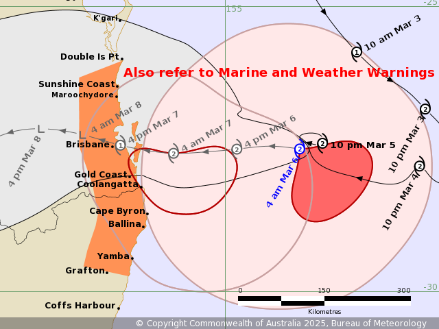
South-east Queenslanders will have to wait a little longer for Cyclone Alfred to make landfall, as the rare category two system continues to slow.
It is now expected to cross over Brisbane tomorrow afternoon and is currently about 300km away.
Meteorologist Helen Reed says there is a strong possibility it could slow even further, but that would give residents more time to prepare for the coming inundation.
A severe weather warning remains in place ahead of Cyclone Alfred’s arrival, with warnings of heavy rainfall that could lead to flooding and damaging winds across the south-east.
For those along the coast, a hazardous surf warning is also in effect.
An evacuation centre will open at the RNA Showgrounds from 7 AM for those in need of refuge.
It will accept residents until midday before being locked down, though it is unclear if that will change now that Alfred’s landfall timeframe has been delayed.
Locals are bunkering down, and services are winding back.
More than 660 schools across the south-east have been shut, deemed too unsafe for children to attend today or tomorrow.
The deadline for collecting sandbags or dropping off green waste has also passed, with council depots and Resource Recovery Centres closing last night.
Brisbane Airport remains open for now, but it will be up to airlines to decide whether to cancel flights. However, the Airtrain to the terminals has stopped.
It’s a different story further south, where the Gold Coast terminal has already closed.
Issued at 4:51 am AEST Thursday 6 March 2025.
Wednesday March 5th
CYCLONE DETAILS
The Prime Minister has touched down overnight, ahead of Cyclone Alfred’s expected arrival.
The category two system is now on a collision course with the coast, on track to make landfall North of Brisbane late Thursday, early Friday.
What Alfred is doing right now.
A severe weather warning’s been issued for the South-East and winds could get up to 120km/hr today in some parts.
FLOODING
New modelling shows 20,000 homes around Brisbane could be impacted by storm surge or flooding tipped to peak from tomorrow.
Suburbs like Nudgee Beach, Brighton, Windsor, Ashgrove, Morningside and Rocklea are most at risk.
You can look up your address on the Brisbane Emergency Dashboard website.
SHOPPING FOR ESSENTIALS
For the first time in Queensland, an emergency declaration’s been made before a natural disaster meaning supermarkets, hardware stores and health services can stock around the clock.
They’ll now be able to restock essentials 24/4 to keep up with demand.
SANDBAGS
Locals are being urged to prepare now with record sandbag collections across the city.
Queensland has ordered another 250,000 to keep up with demand.
142,000 sandbags have been filled in recent days with an extra 250,000 on the way.
Locals have been up before dawn today collecting them to safeguard their homes.
WHEELIE BINS
And your wheelie bin collection? Yep, those are affected too
It’s already stopped in Moreton Bay with Brisbane doing its last round of red-top pick-ups today.
SCHOOLS
Schools are closed as of 11am Wednesday and will remain closed Thursday & Friday. View the view list of closures here.
EVENT CANCELLATION
Green Day say they’re just as bummed out as the fans after the wild weather forced them to cancel their only Queensland show.
They were due to take the stage on the Goldie tonight but say it’s not possible to go ahead safely.
SPORT
The decision to move the Dolphins – Rabbitohs clash down to Sydney on Friday – is being slammed by some partners of players.
Dolphins territory is right in the eye of where Alfred could make landfall. Kody Nikorima’s pregnant wife says it’s disgusting families are being left behind to ride it out alone, some with no support at all.
The AFL on the other hand has postponed Friday’s Lions-Cats clash in Brisbane. Saturday’s Suns-Essendon game on the Gold Coast.
Brisbane coach Chris Fagan says the safety of family and friends and staff and fans is the priority.
Issued at 4:53 am AEST Wednesday 5 March 2025
Tuesday March 4th
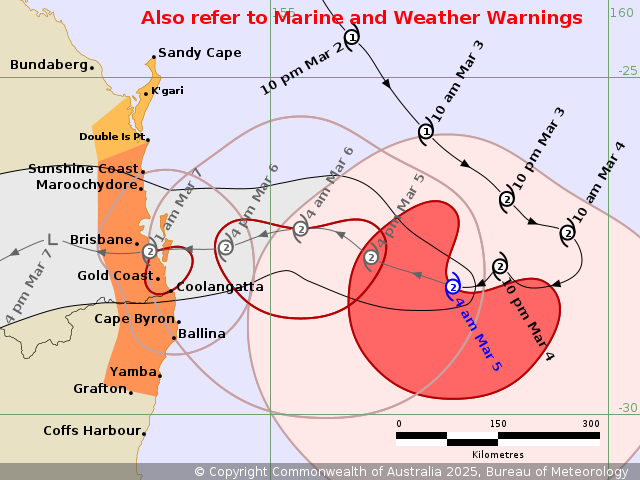
Cyclone Alfred is now tipped to make landfall somewhere between Brisbane and the Sunshine Coast late Thursday or early Friday. It’s still too early to say exactly when or where but it intensified to a Catagory 2 again this morning and is expected to turn towards the coast today as it sits 560kms away from Brissy.
Tropical #CycloneAlfred (Cat 2) is currently located 560km east of #Brisbane and #Maroochydore. It is currently moving southeast but is expected to turn westwards toward the #Qld coast later today.
Latest: https://t.co/QdjBLkJdvZ pic.twitter.com/ElW9n39oVQ
— Bureau of Meteorology, Australia (@BOM_au) March 3, 2025
💻 USEFUL RESOURCES 💻
Get Prepared:
Sandbags can be collected at the following locations:
- Darra – South Depot, 38 Shamrock Road
- Lota Depot, 58 Herbert Street, Lota
- Morningside – Balmoral Depot, 9 Redfern Street
- Newmarket – SES Depot, 66 Wilston Road
- Zillmere-North Depot, 33 Jennings Street.
Free green waste drop off is now available at all 4 resource recovery centres (RRCs) until further notice. Residents are urged to clean up their properties ahead of possible severe weather.
The RRCs are open from 6.30am to 8.45pm every day, located at:
• Willawong – 360 Sherbrooke Road
• Chandler – 728 Tilley Road
• Ferny Grove – 101 Upper Kedron Road
• Nudgee – 1372 Nudgee Road
Get your emergency kit ready!
Download the Get Ready Queensland checklist here
Find out if about school closures here
Register for Brisbane Severe Weather Alerts here


